

Improving sea level anomaly and absolute dynamic topography data sets
- 23 September 2019
- Category: Altimetry, Scientific projects and publications

Sea level anomaly and absolute dynamic topography are important climate variables. CLS is proud to provide these data sets to the Copernicus Marine Environment Monitoring Service (CMEMS) and the Copernicus Climate Change Service (C3S) using DUACS, a CNES/CLS processing system that provides altimetric products. In the article, “DUACS DT-2018: 25 years of reprocessed sea level altimeter products” published in Ocean Science, scientists at CLS, the Instituto Mediterráneo de Estudios Avanzados, and French Space Agency, CNES, explain how the reprocessing of 25 years of altimetric data represents great improvements of sea level products mainly in coastal areas – as well as for geostrophic currents.
Improving altimetry products
Several changes have been implemented in the DT2018 processing in order to improve the quality of the products. New altimeter standards and geophysical corrections has been used, refined data selection has been implemented and Optimal Interpolation (OI) parameters have been reviewed for global and regional map generation.
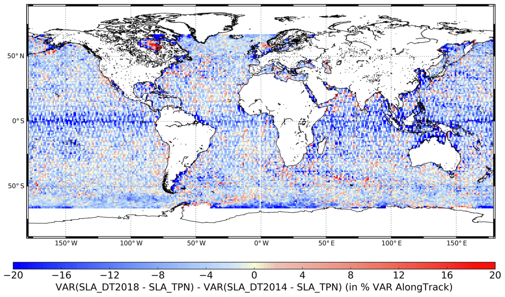
10% error reduction in coastal areas

Through this paper, an extensive assessment has been carried out. The error budget associated to the DT2018 products at global and regional scales has been refined and the improvements compared with the previous version quantified (DT2014; Pujol et al., 2016). The DT2018 errors at mesoscales are reduced by nearly 3 to 4 % for global and regional products compared to the DT2014. This reduction is much more important in coastal areas (reduction is up to 10 %) where it is directly linked to the altimeter geophysical corrections used in the DT2018 processing. Conclusions are very similar concerning geostrophic currents, where error is reduced by 5 % and up to 10 % in coastal areas.
Valuable improvements for climate & ocean circulation studies
Two different types of sea level altimetry products are available in DT2018 version. The first type, produced and distributed within the Copernicus Marine Service (CMEMS), is dedicated to mesoscale observation. The other type, produced and distributed within the Copernicus Climate Change Service (C3S), is dedicated to monitoring the long-term evolution of the sea level for use in climate applications and for analyzing ocean–climate indicators (such as global and regional MSL evolution).
As public attention turns to global sea level rise and the impact this phenomenon will have on coastal communities in the coming decades, it is of crucial importance to provide the most accurate sea level data as possible. The DUACS DT2018 reprocessing will provide valuable data to the scientific community for climate and ocean circulation studies.
Citation: Taburet, G., Sanchez-Roman, A., Ballarotta, M., Pujol, M.-I., Legeais, J.-F., Fournier, F., Faugere, Y., and Dibarboure, G.: DUACS DT2018: 25 years of reprocessed sea level altimetry products, Ocean Sci., 15, 1207–1224, https://doi.org/10.5194/os-15-1207-2019, 2019.